
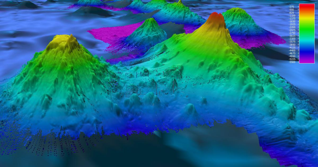
High-resolution ocean floor mapping has emerged as a groundbreaking technology, offering unparalleled insights into the mysterious world beneath our oceans. The development of advanced sonar systems and innovative mapping techniques has transformed our understanding of the ocean floor, paving the way for scientific discoveries, environmental conservation, and improved maritime operations.
Key Points
- Technological Advances: The introduction of high-resolution sonar systems, such as the Autonomous Sparse-Aperture Multibeam Echo Sounder, has significantly enhanced the accuracy and speed of ocean floor mapping. These systems can capture detailed images of underwater landscapes, revealing features that were previously hidden or indistinguishable.
- Applications: This technology has wide-ranging applications, including:
- Scientific Research: Detailed maps of the ocean floor help scientists study underwater ecosystems, geological formations, and tectonic activities.
- Environmental Conservation: Accurate mapping aids in the identification of fragile marine habitats, supporting efforts to protect and preserve these areas.
- Maritime Operations: High-resolution maps improve navigation safety, assist in the planning of underwater infrastructure projects, and enhance search and recovery missions.
- Historical Incidents: The development of high-resolution ocean floor mapping has played a crucial role in several notable incidents:
- Titan Submersible Tragedy (2023): The advanced sonar technology significantly reduced the search time for the Titan submersible, highlighting the critical role of accurate ocean floor mapping in rescue operations.
- MH370 Search (2014): The search for Malaysia Airlines Flight MH370 involved extensive ocean floor mapping, revealing previously unknown underwater features and demonstrating the vast potential of this technology in search and recovery missions.
ALSO READ :- https://virenbrew.com/cybersecurity-in-the-age-of-digital-transformation/
Chart: Ocean Floor Mapping Timeline
| Year | Milestone |
|---|---|
| 1957 | First comprehensive ocean floor map |
| 1977 | Discovery of hydrothermal vents |
| 1985 | Titanic wreck located |
| 2014 | Extensive mapping in MH370 search |
| 2023 | Titan submersible search with advanced sonar |
The ongoing advancements in high-resolution ocean floor mapping continue to unveil the secrets of our planet’s final frontier, offering new opportunities for exploration and conservation. As technology progresses, the depths of the oceans will become less mysterious, unlocking a treasure trove of knowledge and possibilities.
Conclusion:
In conclusion, high-resolution ocean floor mapping is a transformative technology with far-reaching implications. From advancing scientific research and supporting environmental conservation to enhancing maritime operations and aiding in critical search and rescue missions, the benefits of this technology are profound. The ability to capture detailed and accurate images of the ocean floor has revolutionized our understanding of the underwater world and continues to unlock new opportunities for exploration and discovery. As we push the boundaries of technology, the depths of our oceans will become more accessible, revealing the secrets and wonders of the planet’s final frontier.
Follow us on INSTAGRAM – https://www.instagram.com/virenbrew/
Follow us on TWITTER (X) – https://x.com/VIRENbrew
Follow us on LINKEDIN – https://linkedin.com/in/viren-brew-230415328/
Follow us on FACEBOOK – https://www.facebook.com/profile.php?id=61565127137999
Follow us on YOUTUBE – https://www.youtube.com/@VIRENbrew
No responses yet